Inspired by Enceladus' post here, I got a map out (well, up on the screen) to check out the furthest destination I've boated to in each direction. And they are:
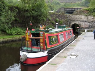
North: Brighouse Basin (Calder and Hebble Navigation), on Andante,
2005 or 2006. I have no photos from this abortive trip from
Huddersfield to Sowerby Bridge, which only got as far as the aforesaid
basin, but here is a picture of dear little Andante.
South: Woking (Basingstoke Canal), on Chertsey, August 2016
East: Downham Market, on Warrior.
West: Ellesmere Port, on Chertsey, Easter 2011
And as a bonus, the lowest and highest points...
Lowest: Holme Fen, (9' below sea level) on Warrior, April 2009.
That's
easy, because it's the lowest point on the entire inland waterways
system - indeed, in the entire country.
No photos of the actual place, but here's our plaque for getting there
(upside down for some reason).
Highest: Standedge Tunnel, (645' above sea level) Andante, 2006
I confirmed this with a useful table
from Pennine Waterways - and this is the highest point on the whole
system. So I may not have visited the most northerly, southerly,
easterly or westerly points (by my rough reckoning, Tewitfield,
Godalming (so should have done that last year instead of sitting in
Weybridge for a week!), Brandon Creek and Llangollen), but I have boated
to both the highest and the lowest. Which is a start.
Some final stats
2 weeks ago


No comments:
Post a Comment